
graphic slider element
Study area: the Doro !nawas mountains
Geography
The IKAi study area is located just a few kilometres from the World Heritage Site /Ui-//aes (Twyfelfontein), which attracts tens of thousands of visitors every year, the Doro !nawas Mountains (southern Kunene region, Namibia (see map). This region is particularly suitable for the envisaged research: it is open, well contoured, particularly rich in game, uninhabited, has a number of permanent waterholes and has not been economically used since decades. But hundreds of spots with engraved rock art show that it has must have been economically exploited in prehistory[1][2]. Today, the Doro !nawas mountains are considered an animal recreational area by the local population.
Geographically, the study area is located within the Namib Desert. Due to the low precipitation (ca. 50 mm annual mean) vegetation is rather sparse. In fact, rainfall in the Namib Desert is extraordinary spotty[3]. In consequence, between 2014 and 2020 almost no rainfall occured in the study area (pers. comm. with people of the Damara living museum, March 2020). But even in years without rain such as 2019 (only 5 mm rain at De Riet in 2019) the region abounds in large game animals. During fieldwork in September 2019 springbok, gemsbok (oryx) , giraffe, ostrich, and zebra were observed while fresh spoor of lion, leopard and hyena were seen in several places. In the dry Huab river – the northern perimeter of the stuey area –also elephants were seen and rhino tracks were found. Due to this highly active, extraordinary wildlife, NGO projects looking after rhinos, desert elephant and desert lions are operating in this region (savetherhinotrust.org; desertelephant.org; desertlion.info).
The Doro !nawas mountains are managed by three conservancies whose borders meet in the study area: the Doro !nawas Conservancy, the /Uibasen Conservancy the Torra Conservancy.
Picture gallery: The study area
Study area: the Doro !nawas mountains, Namib Desert (Kunene Region), western central Namibia.
Archaeology
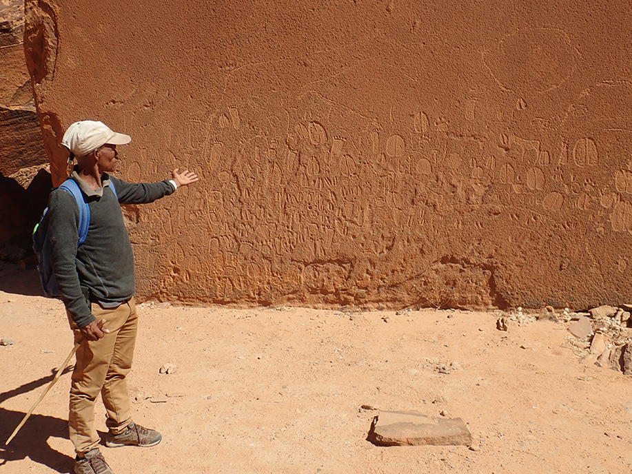
More than 250 rock art sites have been identified and archaeologically documented in the study area in recent years as part of a research project conducted by the Goethe University of Frankfurt[1]. These sites undoubtedly mark fixed points of landscape use by hunter-gatherers over thousands of years in nearby prehistory. So far, however, it remains open how the concrete patterns of movement and paths between these fixed points manifested themselves.
Even if rock art is not to be understood as a 1:1 recording of actual environmental conditions, the art has a high degree of "ecological credibility"[4][5], and the expert reproduction of details about animals and their behaviour shows the profound knowledge and familiarity that the artists had with these animals. These facts further point to the relevance of archaeological sites for the mobility of hunters and gatherers.
Picture gallery: Archaeology
Lokal field names
Since the Doro !nawas mountains are not used economically, only a few names of the landscape elements are known today - also and especially among the local population. For the archaeological work this creates a dilemma: rock art is always connected with conspicuous landscape elements, which are very useful to be able to name in a description of the location. Due to the lack of names for topographical features such as mountains and valleys, it is very difficult to establish references to the landscape or to the sites themselves.
Against this background, IKAi is pursuing a project on a side track and in close cooperation with or under the guidance of the local conservancies (local authorities), in which prominent landscape elements in the vicinity of archaeological sites are given local names before the names, which are alternatively given by archaeologists or adventurers of European origin, are used in mapping.
Local Hunting Traditions
The Doro !nawas mountains and its surroundings are the home of the Damara people. Today, the Damara are no longer allowed to hunt in their home region. The knowledge of many hunting techniques is still available, but the younger generations have no direct hunting experience anymore. Therefore experienced hunters from other cultural groups had to be sought for this research project (see The team). Fortunately, traditional hunting is still allowed in the Nyae Nyae area. Nyae Nyae is the home territory of the Ju/'hoan San, and although here traditional hunting techniques are also rapidly fading, some of the most experienced trackers and traditional hunters are to be found here. Some of these Ju/'hoan trackers are extremely skilled and are – according to the leading trackers certifier Louis Liebenberg – among the top experts of a small group of professionals worldwide.
In order to gain techniques and experience from other cultural groups as well, experienced trackers who learned tracking skills in their youth when traditional hunting was still allowed, e.g. some Shark/'hoan San, also participate in this project.
As the home areas of the Ju/'hoan !Kung San (Nyae Nyae, about 800 km east of Doro !nawas, at the border to Botswana) and Hai//om San (Etosha, about 400 km northeast of Doro !nawas) differ from the Doro ! nawas in landscape, vegetation and topography, following the movements and decisions of the local trackers also provides a rare opportunity to document how hunter-gatherer tracking experts get used to foreign landscapes in terms of orientation, wayfinding and animal behaviour.
Next: Data collection
References
-
Breunig, P., Behringer, J., Fels, M., Maidhof, J., 2019. West of the best: rock art and archaeological discoveries in the Doro !Nawas region of northwest Namibia. Acta Archaeologica 89, 174–192. DOI: 10.1111/j.1600-0390.2018.12199.x
-
Richter, J., 2002. The Giraffe People: Namibia’s Prehistoric Artists, in: Jennerstraße-8 (Ed.), Tides of the Desert -- Gezeiten Der Wüste, Africa Praehistorica. Heinrich-Barth-Institut, Köln, pp. 523–534.
-
Lutz, K., Jacobeit, J., Rathmann, J., 2015. Atlantic warm and cold water events and impact on African west coast precipitation. International Journal of Climatology 35, 128–141. DOI: 10.1002/joc.3969
-
Butzer, Karl W. 1989. Rock Art in the Vaal-Orange River Basin: An Overview, in: Fock, G.J. & Fock, D. (eds.) Felsbilder in Südafrika, Teil III, Die Felsbilder im Vaal-Oranje-Becken. Böhlau Verlag; Köln, pp 137–156.
-
Lenssen-Erz, T., 1997. Metaphors of intactness of environment in Namibian rock paintings, in: Faulstich, P. (Ed.), Rock Art as Visual Ecology. American Rock Art Research Association, Tucson, Arizona, pp. 43–54.